


Photos
")
PINEMAP Map (Original)
This map depicts native loblolly pine range in green; PINEMAP collaborating institutions are noted in blue. Remote sensing image courtesy Google Earth; range map courtesy U.S. Forest Service.


PPINES Met Tower
Weather station tower on an installation of the Forest Biology Research Cooperative PPINES experiment. Photo courtesty of Tim Martin.

Outreach and education
Dr. Tom Fox discusses intensive pine managemnt and carbon sequestration with industrial cooperators. Photo courtesy of John Seiler.

Soil Sampling
Researchers conduct soil sampling in preparatoin for installation of a loblolly pine experiment.

PINEMAP collaborators visit NIFA Headquarters in Washington, DC.
PINEMAP collaborators visit NIFA Headquarters in Washington, D.C.

PINEMAP collaborators discuss integration among research, education, and extension functions.
PINEMAP collaborators discuss integration among research, education, and extension functions.

LiCor
Leaf level gas exchange being measured on clonal loblolly pine at the cross carbon site installed by the U.S. Forest Service and Meadwestvaco. Photo Courtesy of John Seiler.

Soil CO2 Efflux
Researchers conduct spot measurements of total soil CO2 efflux. Photo courtesy of John Seiler.

Loblolly pine harvest
A truck hauls loblolly pine logs from a harvest on the Piedmont National Wildlife Refuge near Juliette, Georgia. Photo courtesy of Tim Martin.

Skidder
A skidder prepares to pick up a turn of loblolly pine logs during a harvest on the Piedmont National Wildlife Refuge. Photo courtesy of Tim Martin.

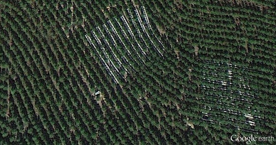
FL Tier III from tower
Throughfall exclusion structures at the PINEMAP Tier III site in Taylor County, FL. Photo courtesy of Geoff Lokuta


